IMPROVE Program
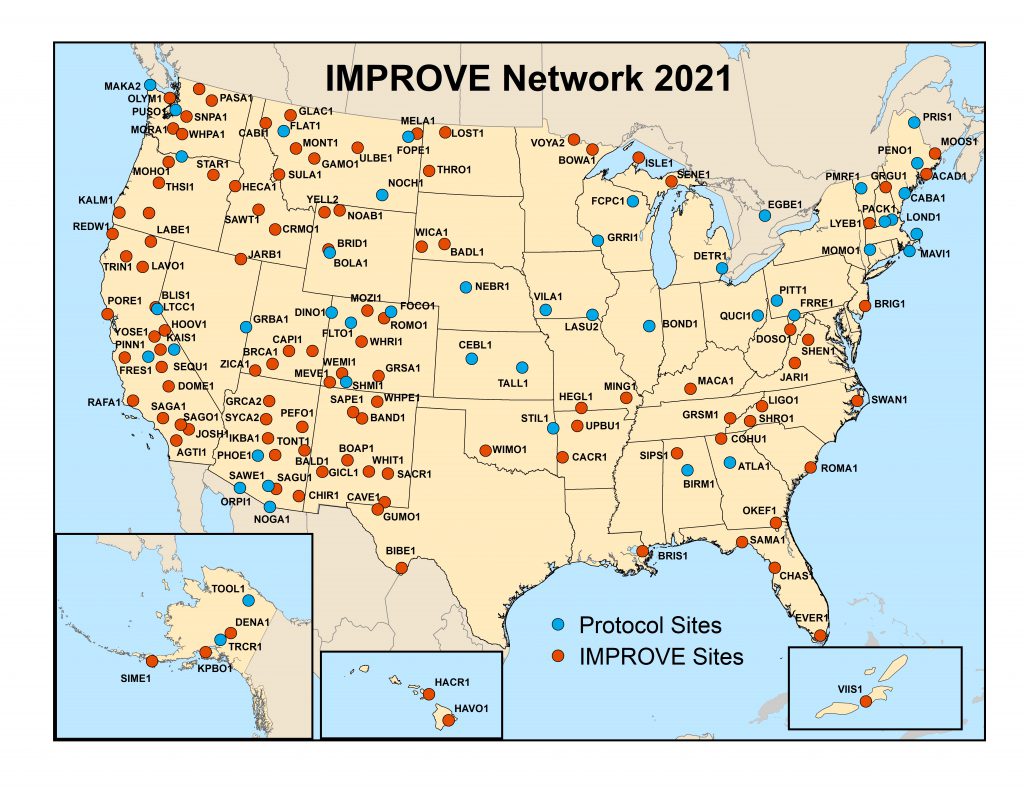
Under the Clean Air Act, Congress recognized that visibility is a resource to be valued and preserved now and for future generations, and set forth a national goal that calls for “the prevention of any future, and the remedying of any existing, impairment of visibility in mandatory Class I federal areas which impairment results from manmade air pollution.” The Regional Haze Rule (RHR) expanded this mandate by requiring monitoring in locations representative of the 156 visibility-protected federal Class I areas. IMPROVE was designated as the visibility monitoring network to be used to carry out this responsibility. IMPROVE was initially established as a national visibility network in 1985, and consisted of 30 monitoring sites primarily located in national parks, 20 of which began operation in 1987. With the implementation of the RHR in 1999, the IMPROVE network expanded, and 110 monitoring sites were identified that were deemed representative of the regional haze conditions for 155 of the mandatory 156 Class I areas, the Bering Sea Wilderness being the exception. In addition to the 110 sites that are used to represent Class I areas, a number of IMPROVE protocol sites are in operation that provide expanded spatial coverage for the network. Protocol sites are separately sponsored by state, regional, tribal, and national organizations and use the same instrumentation, monitoring, and analysis protocols as IMPROVE. The use of identical samplers and analysis protocols by the same contractors ensures that data generated by IMPROVE and IMPROVE protocol sites can be treated as directly comparable.
IMPROVE is a cooperative measurement effort managed by a Steering Committee that consists of representatives from EPA, NPS, USFS, FWS, BLM, NOAA, four organizations representing state air quality organizations (NACAA, WESTAR, NESCAUM, and MARAMA), and three Associate Members: AZ DEQ, Env. Canada, and the South Korea Ministry of Environment. The IMPROVE program establishes current visibility and aerosol conditions in mandatory Class I areas; identifies chemical species and emission sources responsible for existing man-made visibility impairment; documents long-term trends in visibility; and provides regional haze monitoring representing all visibility-protected federal Class I areas, where practical.

IMPROVE samplers collect 24-hour samples, every three days. The IMPROVE particle monitor consists of four independent sampling modules. Three modules (A, B, and C) collect only fine particles (PM2.5), while the fourth (module D) collects both fine and coarse particles (PM10). Modules A, B and C (PM2.5) run at a nominal flow rate of 22.8 LPM, while module D (PM10) runs at 16.9 LPM. Data from all of the modules are used to calculate visibility metrics. Module A is equipped with a Teflon® filter that is analyzed for PM2.5 gravimetric fine mass, elemental concentration, and light absorption. Module B is fitted with a Nylasorb (nylon) filter and analyzed for the anions sulfate, nitrate, nitrite, and chloride using ion chromatography. Module C utilizes a quartz fiber filter that is analyzed by thermal optical reflectance (TOR) for organic and elemental carbon (EC). Module D is fitted with a PM10 inlet and utilizes a Teflon filter to determine PM10 aerosol mass concentrations gravimetrically. Some sites also include a nephelometer for optical monitoring, and a webcam for documenting scenic appearance.