Impairment Overview
Introduction to Impairment
Impairment-Based Regional Haze Metric – Overview Scott Copeland – 02/19/2019
Introduction
Visibility-reducing haze is caused by natural and anthropogenic sources. The Clean Air Act sets a goal of eliminating human-caused visibility impairment from Class I areas, which include certain National Parks, National Wildlife Refuges, and Wilderness Areas, by 2064. The United States Environmental Protection Agency’s (U.S. EPA) original 2003 Guidance for Tracking Progress Under the Regional Haze Rule1 was based on the removal of anthropogenic impairment on the 20% of days each year with the highest total haze (natural and anthropogenic). In the western United States, these days regularly include large amounts of haze from wildfire smoke and windblown dust. Meeting the Clean Air Act goals of removing human-caused haze by focusing on days dominated by sources that are not practically controllable is problematic.
Path Forward
U.S. EPA rule revisions and guidance published in 2016 and 2018 propose a new approach to track progress under the Regional Haze Rule2, which is to select 20% of the sample days from each year that have the highest anthropogenic impairment. These represent the days each year that have the largest apparent change in visibility from what would have existed with no anthropogenic haze and that are expected to be most sensitive to emissions control programs.
The Impairment Framework
Total extinction estimates from each daily IMPROVE sample are split into natural and anthropogenic contributions (see Impairment Framework Split and Sort). Anthropogenic impairment is defined as the difference between the total haze and natural haze, expressed in deciviews. Sorting by anthropogenic impairment produces the same result as sorting by the ratio of anthropogenic to total extinction. A deciview value based on total extinction is calculated for each of the 20% most anthropogenically impaired days. The mean of these values becomes the tracking progress metric for that year.
2064 Endpoints (also see Impairment Framework 2064 Endpoints)
Changing the metric for tracking progress requires new estimates of the 2064 goals in order to calculate the Uniform Rate of Progress. Natural haze levels change from year to year, but the expectation is that the average amount of natural haze on the most impaired days will remain roughly constant over time. Fifteen-year averages of the natural haze levels on the 20% most impaired days are used to derive the endpoint estimates.
Known Limitations
The impairment framework minimizes issues caused by large natural haze events obscuring progress toward natural conditions. However, it introduces the issue of estimating natural haze levels for each IMPROVE sample day, which is challenging. The U.S. EPA draft guidance impairment algorithm relies heavily on National Acid Precipitation Assessment Program estimates of natural visibility conditions (Trijonis, 1990) as well empirical estimates of natural wildfire and dust events. This introduces problems as evidenced by the fact that measurements of organic carbon extinction across much of the eastern United States are already below the NAPAP estimates on an annual average basis. Therefore, the algorithm that splits daily total extinction into natural and anthropogenic contributions assigns all of the organic carbon extinction on every sample day at many eastern sites to the “natural” category.
The splitting of total extinction into natural and anthropogenic contributions to estimate anthropogenic impairment is only performed to sort the data and select the 20% most impaired days. The resultant daily estimates of natural and anthropogenic contributions to haze from each species should only be interpreted within the context of this sorting process and for estimating 2064 endpoints.
Results
The impairment framework provides a metric that is relatively simple to implement and results that are not overly sensitive to the assumptions used to perform the natural/anthropogenic split (e.g., the precise definition of an episodic contribution). In the eastern United States, there is generally little difference between the haziest and most impaired days, with similar temporal trends for both metrics. In the West, sites with insignificant or increased trends in the haziest days metric show modest but steady reductions in haze with the impairment metric.
1 U.S. Environmental Protection Agency. Tracking Progress Under the Regional Haze Rule. EPA-454/B-03–004, Washington, DC, September 2003.
2 U.S. Environmental Protection Agency. Technical Guidance on Tracking Visibility Progress for the Second Implementation Period of the Regional Haze Program. EPA-454/R-18-010, Washington, DC, December 2018. Split and Sort
Impairment Framework – The Split and Sort Scott Copeland – 02/19/2019
Introduction
The Clean Air Act aims to eliminate visibility impairment from anthropogenic sources. Ideally, IMPROVE measurements could be split precisely into contributions from natural and anthropogenic sources. However, current measurement and modeling techniques do not allow for such a determination, and so instead a simple algorithm is used. Results from the split and sort algorithm are not considered to be robust on a daily basis, but the algorithm demonstrates skill at selecting the most impaired sample dates (when evaluated against model results). The total haze on these most impaired days is used to track progress toward Regional Haze Rule goals.
The Split
Each IMPROVE sample is split into three parts: episodic natural, routine natural, and anthropogenic. The episodic natural fraction represents natural events that generate large amounts of haze due to wildfire and dust. This fraction is estimated by assuming that all carbon (organic + elemental) and dust (fine soil + coarse mass) above certain extinction thresholds are natural. Carbon and dust thresholds are determined for each site by taking the minimum of the annual 95th percentile value for that site from 2000 through 2014. For carbon, typical thresholds are 5–20 Mm-1; for dust, 2–10 Mm-1.
The routine natural fraction is based on the default natural conditions estimates from the U.S. Environmental Protection Agency’s 2003 Guidance for Estimating Natural Visibility Conditions Under the Regional Haze Rule1. After removing episodic natural events, each year’s measured annual mean extinction for each of the seven species is scaled to the default natural condition estimate as follows:
- daily routine natural = (default natural estimate/measured non-episodic annual mean) × daily non-episodic extinction
The ratio of default natural estimate to measured non-episodic annual mean is limited to values ≤1. The resulting product is considered routine natural and, if averaged over any year, will be less than or equal to the default natural estimate. All sea salt extinction and Rayleigh scattering are added to the natural fraction. The portion of each species, each day, that is not assigned to a natural category is assumed to be anthropogenic.
Anthropogenic impairment is then the difference between total and natural (sum of routine and episodic) haze expressed in deciviews. Anthropogenic impairment is the sorting parameter used to determine which days are “most impaired.” This sort is equivalent to sorting the days by the ratio of anthropogenic to total extinction.
The Sort
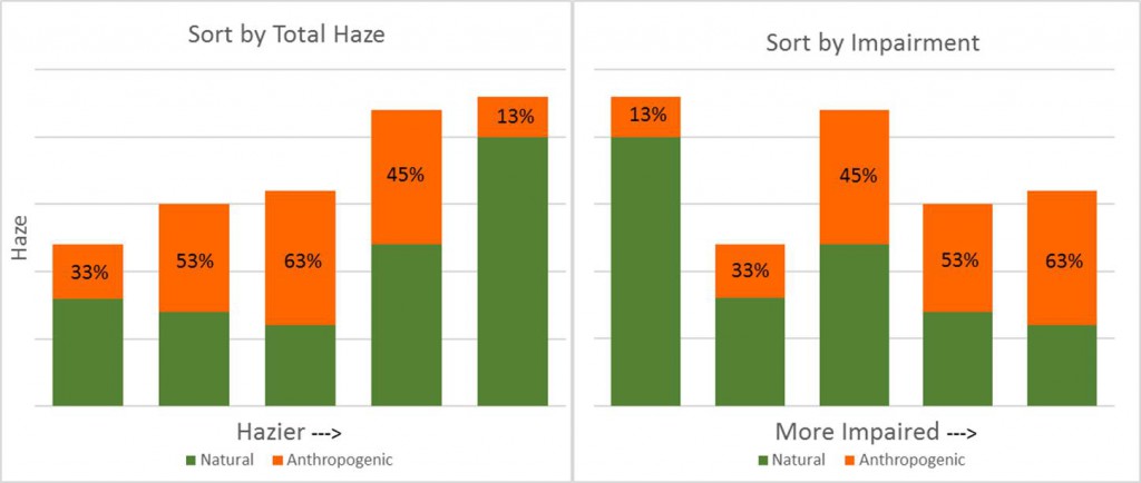
Days are sorted by the fraction of haze that is anthropogenic, as illustrated in the right plot of Figure 1. This is compared with the previous tracking progress metric, which used total haze to sort (left plot). The deciview values based on total extinction on the 20% most impaired days are averaged and become the new metric for tracking progress.

Figure 1. Each vertical bar is a sample day split into anthropogenic and natural extinction. On the left, highest haze days can include large fractions of natural haze, whereas on the right, days sorted by the fraction of anthropogenic haze generally do not. Vertical axis is haze in inverse megameters and horizontal axis is the sorting metric.
1 U.S. Environmental Protection Agency. Guidance for Estimating Natural Visibility Conditions Under the Regional Haze Rule. EPA-454/B-03–005, Washington, DC, September 2003. Impairment Framework 2064 Endpoints
Impairment Framework – 2064 Endpoints Scott Copeland – 02/19/2019
Introduction
The impairment-based tracking metric requires a new 2064 target condition, since the previous estimates of 2064 natural conditions were based on the haziest natural days, not the most impaired days. In its 2016 rule revision1, the EPA specified that 2064 conditions could be adjusted to include international anthropogenic contributions to the extent that they could be accurately estimated and prescribed burning under certain circumstances. This makes the term “natural conditions” inappropriate, hence the term “endpoints”.
2064 Endpoint Rationale
The ideal endpoint for the new glide slope would be one that represents extinction from natural sources (episodic and routine), as well as international contributions and prescribed burns, as appropriate. The impairment framework provides daily estimates of episodic and routine natural extinction on the most impaired days. When averaged over many years, the natural contributions on the most impaired days are fairly uniform temporally and spatially and provide reasonable default values for these endpoints.
Calculating Default 2064 Endpoints
Endpoints are determined for each site by calculating a daily deciview value based on the sum of episodic and routine natural extinction (including sea salt and Rayleigh scattering) for the 20% most impaired days. These daily deciview values are averaged for each year, and the annual averages over the 2000–2014 period are further averaged for years with sufficient data completeness.
Results
Recommended 2064 endpoints provide a consistent starting point for generating a glide slope to track progress within the impairment framework. As with the default natural conditions defined in the original guidance for tracking progress, considerable uncertainty exists in these endpoints, especially at sites with significant, large natural sources nearby. The 2064 endpoint values are generally lower than the previous natural conditions II haziest day estimates and higher than the natural conditions II annual means. They are spatially fairly uniform within two distinct regions; eastern and western.
The 2064 endpoints do not yet reflect international anthropogenic contributions or prescribed fire but may in the future.
1 U.S. Environmental Protection Agency. Draft Guidance on Progress Tracking Metrics, Long-term Strategies, Reasonable Progress Goals and Other Requirements for Regional Haze State Implementation Plans for the Second Implementation Period. EPA-457/P-16-001, Washington, DC, July 2016.

