The Pacific Northwest Regional Visibility Experiment Using Natural Tracers (PREVENT)
Background
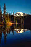
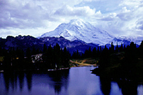
An intensive field monitoring program was undertaken during the summer of 1990 to study the contribution of emission sources to ambient particulate concentrations and regional haze at Federal Prevention of Significant Deterioration (PSD) Class I areas in the state of Washington. These areas included the national parks, managed by the National Park Service (NPS), namely Mount Rainier, North Cascades, and Olympic, and the wilderness areas managed by the U.S. Forest Service (USFS), namely Pasayten, Glacier Mount Rainier National Park was established in 1899 with 235,625 acres (97% is designated Wilderness). Includes Mount Rainier (14,410′), an active volcano encased in over 35 square miles of snow and ice. The park contains outstanding examples of old growth forests and subalpine meadows. The park was designated a National Historic Landmark District in 1997 as a showcase for the “NPS Rustic” style architecture of the 1920s and 1930s. Nearly two million visitors come to enjoy the grandeur and beauty of Mount Rainier each year.
The primary objectives of PREVENT were to:
- Determine the spatial and temporal patterns of aerosol concentration, chemical composition and particle size; regional emissions; and light extinction and observed visual effects.
- Determine estimates of the light extinction budgets for the summer period for Mount Rainierand North Cascades National Parks.
- To apportion (or attribute) the summertime haze observed in Federal Class I areas in Washington to the regional emissions from all sources in the Pacific Northwest and British Columbia.
- To determine the contributions from natural and man-made sources.
Reports
Final Report: The Pacific Northwest Regional Visibility Experiment Using Natural Tracers